
Mexico City is located in the Valley of Mexico, sometimes called the Basin of Mexico. This valley is located in the Trans-Mexican Volcanic Belt located in the high plateaus of south-central Mexico. It has a minimum altitude of 2,200 meters (7,217 feet) above sea level and surrounded by mountains and volcanoes that reach elevations of over 5,000 meters. This valley has no natural drainage outlet for the waters that flow from the mountainsides, making the city vulnerable to flooding. It was artificially opened through the use of canals and tunnels starting in the 17th century. The city primarily rests on what was Lake Texcoco. Seismic activity is frequent here. This lake was drained starting from the 17th century and while none of its waters remain, the city rests on its heavily saturated clay. This soft base is collapsing due to the over-extraction of groundwater and since the beginning of the 20th century, the city has sunk as much as nine meters in some areas. This sinking is causing problems with runoff and wastewater management, leading to flooding problems, especially during the rainy season. The entire lakebed is now paved over and most of the city's remaining forested areas lie in the southern boroughs of Milpa Alta, Tlalpan and Xochimilco.
| Geophysical maps of the Federal District | |||
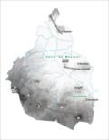 | 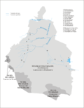 | 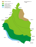 | |
| Topography | Hydrology | Climate patterns | |
Climate

Mexico City has a subtropical highland climate (Köppen climate classification Cwb), due to its tropical location and high elevation. The lower region of the valley receives less rainfall than the upper regions of the south; the lower boroughs of Iztapalapa, Iztacalco, Venustiano Carranza and the west portion of Gustavo A. Madero are usually drier and warmer than the upper southern boroughs of Tlalpan and Milpa Alta, a mountainous region of pine and oak trees known as the range of Ajusco.
The average annual temperature varies from 12 to 16 °C (54 to 61 °F), depending on the altitude of the borough. Lowest temperatures, usually registered during January and February, may reach -2 to -5 °C (28 to 23 °F), usually accompanied by snow showers on the southern regions of Ajusco, and the maximum temperatures of late spring and summer may reach up to 32 °C (90 °F). Overall precipitation is heavily concentrated in the summer months, including dense hail. The central valley of Mexico rarely gets precipitation in the form of snow during winter; the two last recorded instances of such an event were on March 5, 1940 and January 12, 1967.
The region of the Valley of Mexico receives anti-cyclonic systems, whose weak winds do not allow for the dispersion, outside the basin, of the air pollutants which are produced by the 50,000 industries and 4 million vehicles operating in or around the metropolitan area.
The area receives about 820 millimetres (32.3 in) of annual rainfall, which is concentrated from June through September/October with little or no precipitation the remainder of the year. The area has two main seasons. The rainy season runs from June to October when winds bring in tropical moisture from the sea. The dry season runs from November to May, when the air is relatively drier. This dry season subdivides into a cold period from November to February when polar air masses pushing down from the north keep the air fairly dry and a warm period from March to May when tropical winds again dominate but they do not yet carry enough moisture for rain.
No comments:
Post a Comment